How the Blueprint is helping support conservation and the military mission
The intersection of conservation and the military mission has emerged as a prominent theme in our recent work with user support. The user support team has assisted with several use cases lately where the military community has used the Southeast Conservation Blueprint and other complementary data to strengthen proposals to establish new Sentinel Landscapes, and to inform conservation planning to better sustain both natural and cultural resources and the military mission. I thought this would be a good topic for a “user story roundup” to share some examples of how the Blueprint can help advance shared goals in this arena!
-
A team including the Department of Defense, Middle Georgia Regional Commission, and Stantec is incorporating the Southeast Blueprint into the Middle Georgia-Robins Air Force Base Sustainability Plan, a document intended to facilitate collaboration and compatible development between the Base and the surrounding communities. In the current draft, the Blueprint has contributed to the Environment and Cultural Resources chapter by helping identify priority natural areas in need of conservation within a 10-mile buffer surrounding the base. This chapter of the draft plan also recommends using the Blueprint as part of a more in-depth follow-up study to identify priority natural areas for future protection. The first public meeting for the Sustainability Plan is scheduled for August 5th, so if you’d like to participate, visit the Get Involved page of the plan website to learn more.
-
The North Carolina Strategic Plan for Sustaining Military Readiness Through Conservation Partnerships, affectionately known as “Spaces Between the Bases”, is using the Blueprint to help map areas that are important for both conservation and sustaining military readiness in North Carolina. The project will further evaluate how future threats like urban growth and climate change will impact these spaces between the bases, exploring scenarios and potential responses that could affect both the future flexibility of military readiness and the future availability of conservation co-benefits. In addition to the Blueprint, the conservation importance layer is incorporating data from the NC Natural Heritage Program, the NC State Wildlife Action Plan, The Nature Conservancy, and more.
-
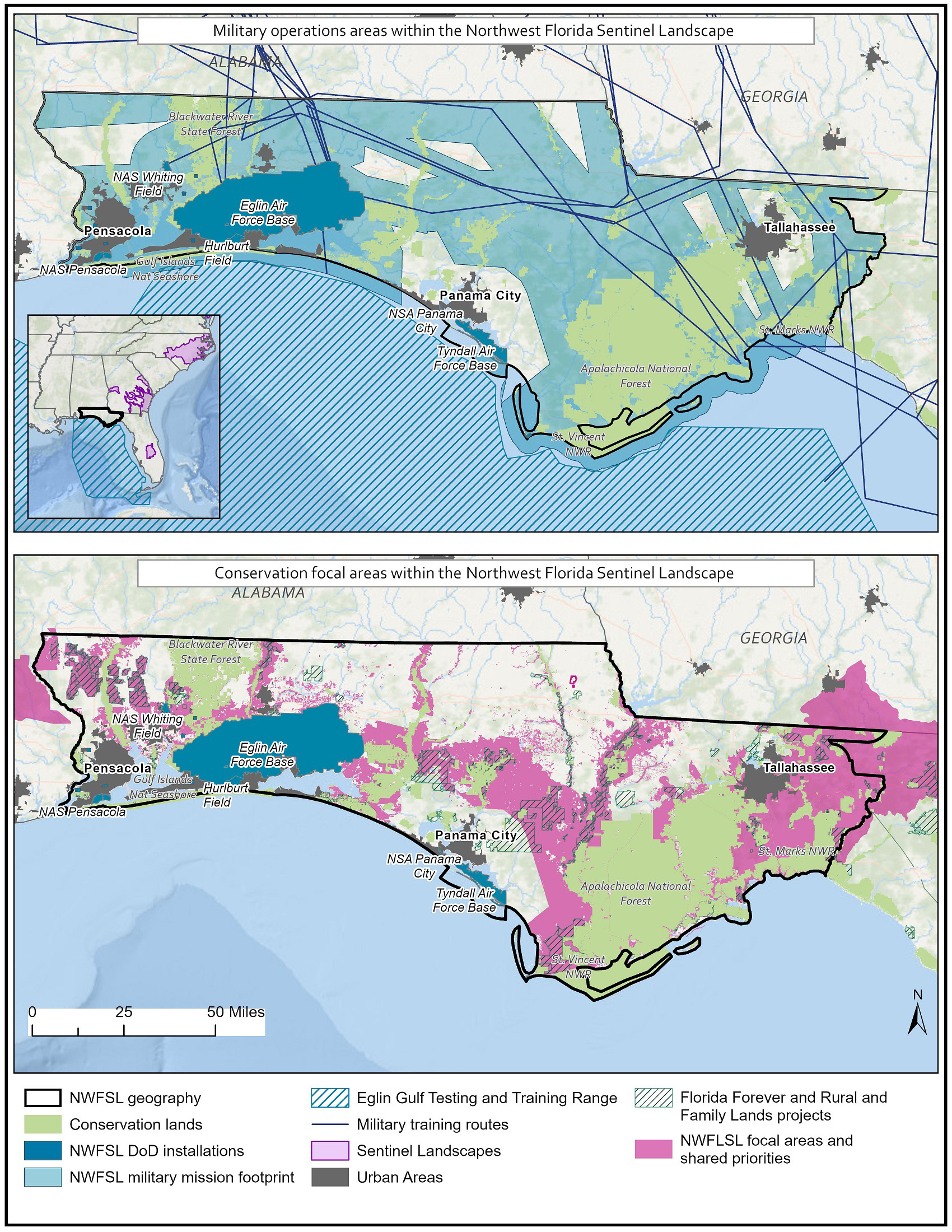
The newly designated Northwest Florida Sentinel Landscape used the Blueprint to help define conservation focus areas within their geography, which are areas of alignment between conservation priorities and the military mission footprint. To strengthen the successful application to establish the Northwest Florida Sentinel Landscape, user support also developed maps, provided connections to the SECAS Goal, and incorporated climate change and urbanization projections. In addition, back in 2016, the Blueprint supported the designation of the Eastern North Carolina Sentinel Landscape, and user support is currently assisting with the proposal for a South Carolina Lowcountry Sentinel Landscape.
-
Last April, the U.S. Fish and Wildlife Service, Department of Defense, and University of Florida released the Florida Strategic Plan for Sustaining Military Readiness through Conservation Partnerships–an analog to the similar plan for North Carolina described above. This plan is intended to ensure that Florida Air Force installations are able to continue their essential military mission activities while advancing landscape-scale conservation. It used the Blueprint to help identify areas of overlap between military and ecological priorities that also offer the best potential protection opportunities and are threatened by development and sea-level rise. You can learn more about this partnership on the project website. The final report is available on request from the Panama City Ecological Service Field Office.
-
The Southeast Regional Partnership for Planning and Sustainability (SERPPAS) incorporated the Blueprint into their “Good Map” depicting the priorities of many different partners. The SERPPAS Good Map is intended to identify areas of overlapping priorities at the intersection of protecting military readiness, conserving natural and working lands, and sustaining communities, where collaboration can benefit multiple partners. You can learn more about the Good Map on the SERPPAS maps webpage. SERPPAS Coordinator Addie Thornton blogged about this work back in April 2019, as did Blueprint Coordinator Rua Mordecai the following month.