Who used the Blueprint in 2019 - A Southeast Blueprint user roundup

Let’s ring in the new year by looking back at who used the Southeast Blueprint in 2019! We’ll get into a few stories in detail, but first, as NPR’s Kai Ryssdal says on Marketplace, “let’s do the numbers.”
So far, over 150 people from 70 different organizations have used, or are in the process of using, the Southeast Blueprint—and that’s just the folks we know about! That gives me the tough job of choosing a few highlights, since I can’t squeeze them all into one blog post. I narrowed it down to four that span the Caribbean, Middle South, South Atlantic, and Appalachian subregions.
-
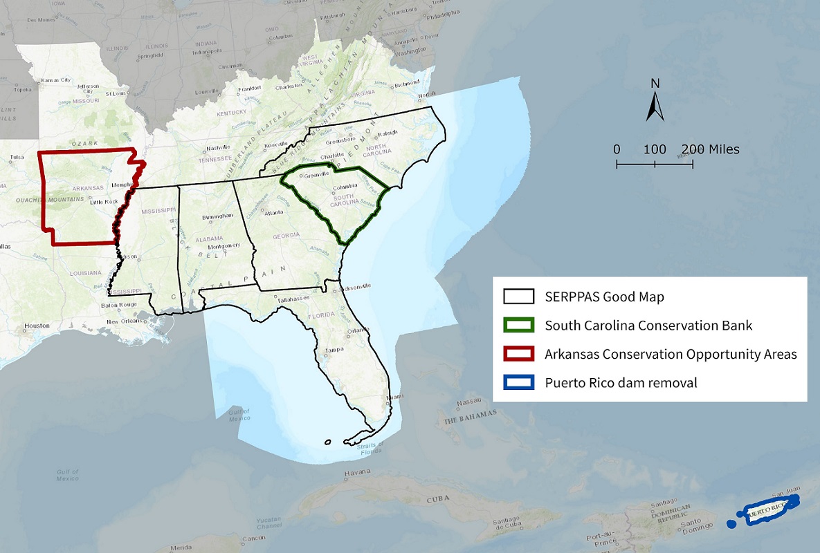
In Puerto Rico, the Southeast Blueprint played a role in facilitating a major dam removal in the Rio Grande de Arecibo watershed. The Blueprint identifies this watershed as high value because of its importance for groundwater and surface water resources and potential for improving connectivity between lands and waters. SECAS partners identified this low-rise dam as a key barrier to aquatic connectivity in the region. The Cambalache dam’s removal last year is an important step toward implementing the Blueprint in the Caribbean. You can read more about the Cambalache Dam removal (and see before and after pictures!) in the SECAS in Action story map.
-
The Arkansas Game and Fish Commission used the Southeast Blueprint last year to develop Conservation Opportunity Areas (COAs) for its State Wildlife Action Plan update. COAs are areas that offer the best opportunities for conserving Species of Greatest Conservation Need. The Southeast Blueprint served as a foundational dataset to map habitat condition and partner priority areas. You can read more about this Blueprint use in Todd Jones-Farrand’s blog from back in August.
-
Over the last couple of years, the Blueprint has been making a major impact in guiding collaborative conservation in South Carolina. Back in 2018, the South Carolina chapter of The Nature Conservancy (TNC) used the Blueprint as a foundational dataset to update to the SC Conservation Vision, which is their statewide map of conservation priorities. That Conservation Vision helped support the reauthorization of a major state land conservation fund, the SC Conservation Bank. In 2019, this exciting Blueprint use went a step further! The SC Conservation Bank used the Blueprint to inform statewide conservation priority maps that will guide where those funds are spent.
-
The Southeast Regional Partnership for Planning and Sustainability (SERPPAS) also included the Blueprint in their “Good Map,” which identifies overlapping priorities for ensuring military readiness, conserving natural and working lands, and sustaining communities. SERPPAS is a regional partnership working at the intersection of national defense, natural resource conservation, and sustainable working lands and communities. To learn more about this Blueprint use, check out the blog SERPPAS coordinator Addie Thornton wrote last April, and the follow-up Rua wrote in May.
We’re currently working on a lot of other great stuff, like:
- Using the Blueprint to identify key natural and cultural resource values in the Ocmulgee River corridor in Georgia to inform several ongoing projects
- Helping the NC Wildlife Resources Commission use the Blueprint to develop a more proactive land acquisition strategy
- Supporting Sumter National Forest’s collaborative “Promise of the Piedmont” initiative by using the Blueprint to strengthen their Land Water Conservation Fund proposals …and so much more!
Does this make you want to use the Blueprint and get in on the fun? I hope so! As always, user support is totally free. Reach out to the user support lead for your state. We’d love to hear from you.