2023 Blueprint workshops by the numbers - Participation and polling
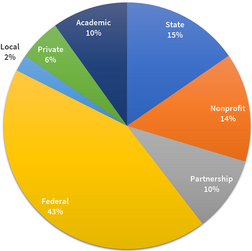
Last month, we wrapped up two exciting weeks of virtual workshops to review draft Southeast Blueprint 2023 in the U.S. Caribbean and the offshore Atlantic and Gulf marine environment. Thanks so much to the 91 people from 45 organizations who participated! Especially given the more narrow geographic focus of this year’s workshops (compared to last year’s, which covered all 15 Southeast states), we had a great turnout. The chart above shows how attendance broke down by sector.
As usual, the primary goal of the workshops was to get spatially explicit feedback on the Blueprint priorities. If you want to learn more about the suggestions we received and how we’re working to incorporate them into the final Blueprint, visit Rua’s blog. When we bring together such a wide swath of the conservation community, we like to take full advantage of the opportunity to discuss other topics, too. This year, we asked for recommendations on how best to refer to different parts of the Blueprint and how best to structure the data download package.
As we extended consistent methods and indicators to the U.S. Caribbean this year, we quickly realized we need a short and sweet way to distinguish between 1) the portion of the Blueprint that covers Puerto Rico, U.S. Virgin Islands, and the surrounding marine environment and 2) the portion of the Blueprint that covers 15 Southeast states and surrounding federal waters. Because, goodness knows, what I just wrote is way too long!
To be clear, we aren’t talking about releasing separate products here–we’ll continue to refer to the primary product of SECAS as the Southeast Conservation Blueprint–but for things like naming indicators, writing documentation, and labeling the data download package, we need a reasonable shorthand for these different geographies. “Caribbean Blueprint” seems to be working fairly well for the first area, but for the second, staff were having trouble choosing between a number of options–mainland Southeast? Contiguous Southeast? Continental Southeast?
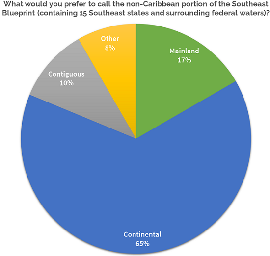
As you can see, when we aggregated the poll results across all workshops, the term “continental” emerged as the clear winner. The discussion we heard at workshops was incredibly helpful for understanding the reasoning behind that preference. For many people, “mainland” seemed to imply a value judgement where the Southeast states are the “main” part of the Blueprint and the Caribbean territories are an afterthought, which is not what we want to convey. The “land” part of mainland also didn’t immediately evoke the fact that the marine environment is included. “Contiguous” felt a bit too technical, and also had an exclusionary connotation, as some associated that word with data products and policies that leave out places like Alaska, Hawaii, Puerto Rico, and the U.S. Virgin Islands. By comparison, “continental” appeared to feel more plain language and like a less loaded term.
Another side effect of expanding the Blueprint and underlying data to more of the U.S. Caribbean and marine environment is that the total size of all that data keeps increasing! For Blueprint users who prefer to download the data for use in desktop GIS, we want to prevent the full package from becoming too unwieldy. One of our key questions was: how many people would use just the continental or Caribbean portions of the Southeast Blueprint independently, vs. using the combined data across the full region? For those that might need just one or the other, having to download the rest of the data could pose an unnecessary hassle.
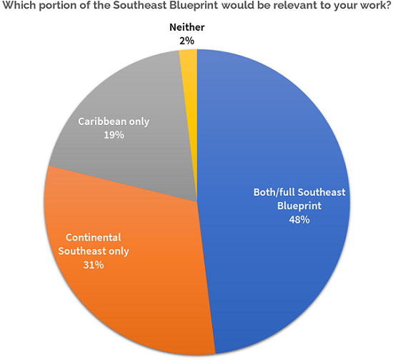
We found that about half of the workshop attendees would use the data for the full Southeast Blueprint, both continental and Caribbean combined. That tells us that we definitely need a combined data download package where all the data is together in one place. But there are still folks who would just use one part or the other, and we want to meet their needs, too!
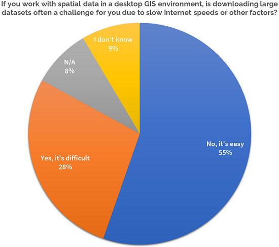
Our next question was about internet speed and barriers to downloading large datasets. We wanted to know: are we right in thinking that download speeds could be a challenge for some folks? The answer to that was yes for roughly a third of workshop participants.
Lastly, we asked attendees to tell us where they typically max out on file size when downloading data. Is there a point where the download package would get too big for many of our users? As you can see, that maximum file size really varies a lot, and plenty of folks weren’t sure.
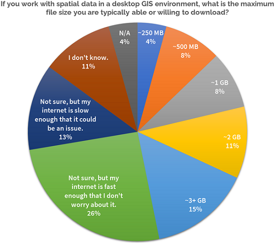
So what do we take away from these last three questions? This year, we’re planning to serve up two different data download package options: one for the full Southeast Blueprint (continental and Caribbean together), and another for just the Caribbean data on its own. Because it covers a much smaller geographic area, the file sizes for the Caribbean data are also much smaller. As a result, a separate download package for the Caribbean will be very manageable, somewhere along the lines of a couple hundred MB.
On the flipside, because the continental Southeast data covers such a huge area, the files are naturally much larger, and there’s only so much we can do to shrink it down–it’s going to be somewhere in the neighborhood of 1.4 GB. Adding in the Caribbean data with the continental Southeast download meets the needs of the large user base who want to use the full Southeast Blueprint, and adds only a trivial amount of additional size for those who just need the continental data in isolation.
I hope that sheds some light on what insights SECAS staff took away from workshops this year, beyond just feedback on the Blueprint itself! As always, we’re so grateful that y’all keep showing up to share your expertise, your time, and your lessons learned to help improving this partnership and its products! If you have additional feedback or thoughts on what I shared here, you can always reach out to me at hilary_morris@fws.gov.