Southeast Conservation Blueprint 2022 is now available!
The latest update to the Southeast Conservation Blueprint, version 2022, is now available!
Big thanks to the 234 people from 80 organizations who attended workshops and provided feedback on the draft version. Part of that feedback was spatial comments on where the Blueprint could be improved. In the final version, we managed to either fully or partially fix about 40% of them (88 total!). The known issues we couldn’t fix this year are now documented on the website and included in the Blueprint development process.
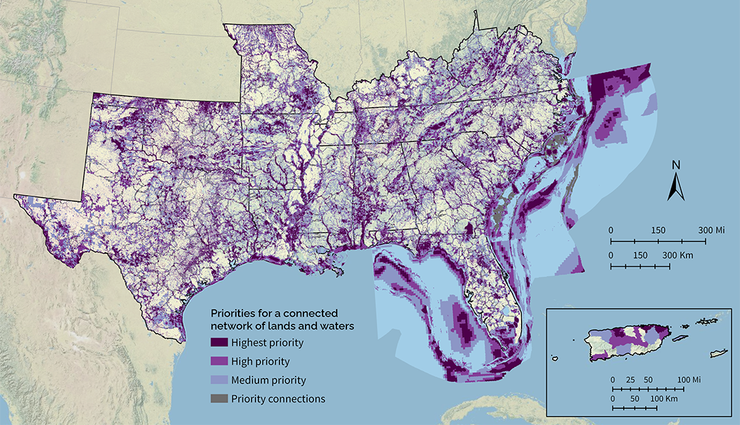
This year’s update was a big step forward for the Southeast Conservation Blueprint. Just like previous versions, it still identifies priority areas for a connected network of lands and waters. The big difference this year is that it now uses consistent methods across 15 states. That includes a suite of natural and cultural resource indicators representing terrestrial, freshwater, and marine ecosystems. It also includes a connectivity analysis that identifies corridors linking coastal and inland areas and spanning climate gradients.
The Blueprint data and documentation are now available on the Blueprint page of the new SECAS Atlas. The SECAS Atlas is a new online mapping platform built in ArcGIS Hub. On the atlas, you can download the data and documentation, view individual indicators, and make maps with Blueprint layers and other data. There’s even a quick start map that includes all the indicators and other Blueprint data.
We’re also close to updating the Blueprint Explorer with the 2022 data. The explorer is more of a Google Maps style interface that lets you quickly summarize and explore Blueprint information. This is also the interface that lets you upload shapefiles and get fancy reports with things like indicator tables/maps and information on sea-level rise and urban growth for your specific area. While we put the finishing touches on the explorer update, you’re welcome to request a Blueprint 2022 report by contacting a member of the user support team. We’re also happy to help if you’d just like some assistance with incorporating this latest version of the Blueprint into your work.
What’s coming up for 2023? We’re always working on improving the Blueprint. The focus for 2023 is extending the consistent methods to Puerto Rico, the U.S. Virgin Islands, and the rest of the U.S. waters in the Gulf. We’ll also be continuing close collaboration with the Midwest Landscape Initiative. Expect to see similar methods and indicators when they release the first version of a Midwest Conservation Blueprint in summer 2023.