Breaking down barriers to conservation action - The role of Blueprint user support
We need more–more people, groups, and organizations putting conservation actions on the ground. We’ve lost too much, and there’s more to lose if we don’t take advantage of our biggest resource to connect lands and waters, which is people. Conservation tools, especially spatial plans, help us organize actions so we can make progress towards connecting lands and waters to support ecosystem function, connectivity, and health. But sometimes those tools fail to be accessible, equitable, and actionable.
Geospatial data, or information that is mappable, is a critical element in conservation planning and as a tool to communicate why an area is important for conservation action. Sometimes, the ways that we create or present this data–data meant to help people put actions on the ground–make it hard to use. Spatial data can be limited to only those who have specific training, have access to expensive software licenses, or have a specific environmental science or natural resource background. This can limit access, and therefore equity and action. The data can also be poorly communicated and difficult to understand, even with easy access and the needed skillset. And that’s putting it kindly.
It can take a lot of effort, sometimes too much effort, to understand what spatial data means, how it can be applied, and what its weaknesses are. You can find yourself debating if the juice is worth the squeeze or if you’ll be able to appropriately communicate the information to other people. These are barriers to conservation action.
For all of these reasons and more, the Southeast Conservation Blueprint comes with a free service to help people overcome the data barriers. We lovingly call this service “user support”. But people often ask, “what exactly is that?”
The answer is that user support staff do a lot of different things at various scales. User support is a different type of role than many we see in conservation. At its core, Blueprint user support clears barriers and offers help to anyone interested in using the Blueprint to support a conservation action. We support any type of user (local municipalities, private companies, state agencies, local nonprofits, large nonprofits, federal agencies, etc.) and any type of conservation action (including restoration, management, planning, etc.). There are three tenets that guide our scope of work:
- Help people/organizations use, navigate, and understand the Blueprint.
- Work to revise and improve the Blueprint based on feedback from people.
- Make the Blueprint easier to use.
What this looks like in practice varies. Ultimately, user support is a team of multidisciplinary staff that work with people across the Southeast to:
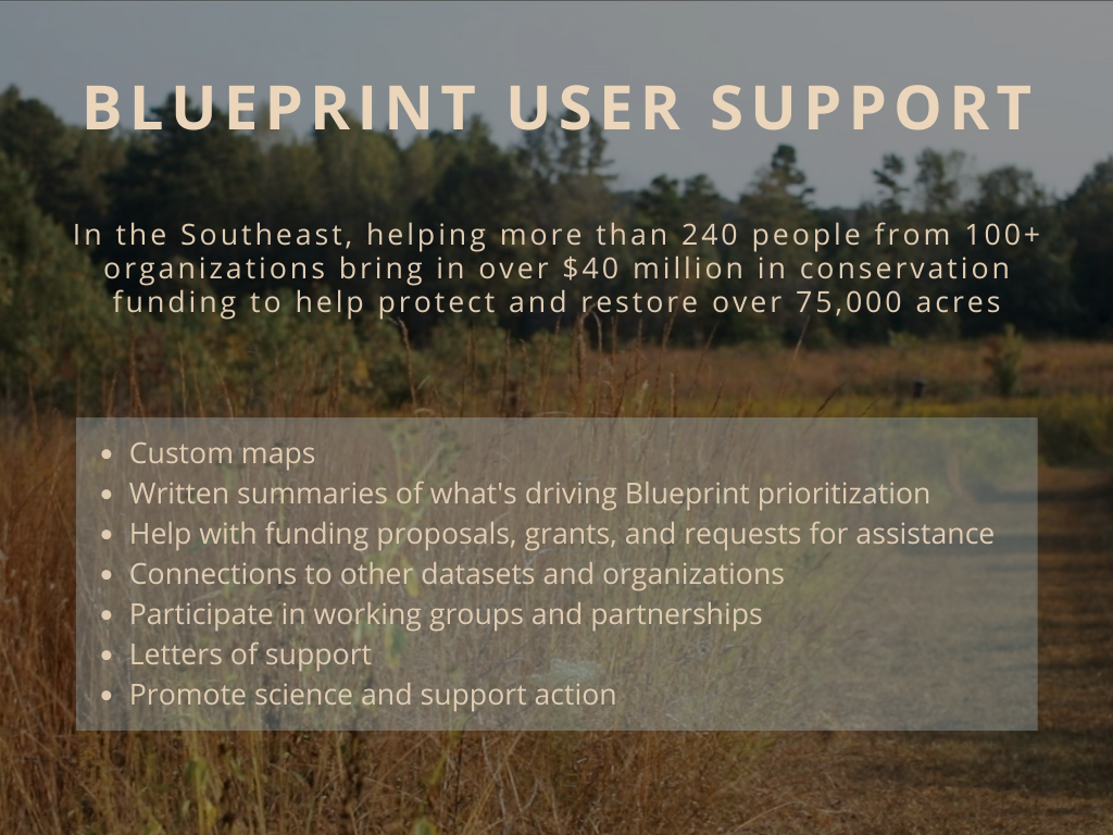
- Make custom maps, including maps that show where the Blueprint identifies important lands and waters at the scale at which you work. We also make maps that include potential threats, like sea-level rise, as well as maps that showcase other datasets, like resiliency.
- Write summaries of what is driving Blueprint priorities in your areas of interest.
- Contribute to funding proposals, grants, and requests for assistance by using the Blueprint to tell a story of how your desired conservation action fits into a wider regional strategy to connect lands and waters.
- Connect people to other datasets, organizations, and efforts that may help support action.
- Help people use the Blueprint in ways that complement other data and local knowledge.
- Participate in working groups and partnerships where the Blueprint can support the alignment of multiple priorities.
- Provide letters of support on behalf of SECAS to conservation initiatives that align with the Blueprint and support a connected network of lands and waters.
- Help brainstorm ways the Blueprint can help advance a goal.
- Help promote science, action, and the Blueprint through hosting web forums, symposiums, and presentations.
But probably one of the most important roles user support staff provide is advocating for the people responsible for putting conservation actions on the ground in terms of listening to and understanding what information they need and how they need it presented. That’s why we call it user support–because it’s the people using the data to inform their actions that will get us to our common goals.
For example, if someone is interested in using the Blueprint and wants to explore it (through the Beta Viewer or the Conservation Planning Atlas, the first thing they will see is a map of Southeast states and Puerto Rico with about half of the lands and waters colored in various shades of blue. Through our viewers and based on user feedback, we try to present information in easy-to-understand ways to explain why an area is a priority and what that means. We want people to be able to figure out what the colors mean and be able to use the information to help their efforts. Sometimes we fail at this and sometimes we do an okay job of it.
User support staff understand that to be thrown into a “map of conservation priorities” is a lot, and just because we offer a lot of information to explain the Blueprint doesn’t mean you have to do all the heavy lifting. You can use it, read it, or dig into by yourself and with your team. Or, you can also contact user support staff and we will listen to what you need and try our best to help and support your conservation efforts. That’s the job. That’s what we do.
Why do we this? Well, helping people is the currency of our work–we track every time we help someone or organization use the Blueprint. We also track when someone tries to use the Blueprint and it doesn’t work. By investing in staff to understand how people use the Blueprint and to make it easier to use, we can potentially increase the effectiveness conservation in the South–by helping bring in new resources, make projects happen, and target actions in a more strategic way. Through user support, we can increase access and support data equity in conservation. We can also learn how to make the Blueprint a better product.
If you’re interested or in need of any of the services Blueprint user support can provide, please contact the user support lead for your state. We’re here to help.