SE FireMap 1.0 now available
There’s some great new mapping data on fire across the 9-state longleaf range now available. It’s what we’re using for the 2021 update to the regularly burned indicator used in the South Atlantic Blueprint, which will be incorporated into Southeast Blueprint 2021 this fall. While it’s certainly not perfect, it’s a big improvement over what we had before for fire. In some early test runs of the 2021 South Atlantic Blueprint, this new data is helping highlight some great longleaf on private and public lands that was missed in the current Blueprint.
Huge shout out to Bridgett Costanzo (NRCS), Lucas Furman (Longleaf Alliance), and Joe Noble (Tall Timbers) for not just making this project happen, but also working really hard to make this Version 1 data available. As many of you know, it typically takes many years before projects like this are allowed to release any results. They worked really hard to share this v.1 product.
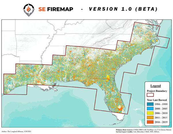
In 2020, the U.S. Department of Agriculture (USDA) Natural Resources Conservation Service (NRCS) provided funds through an agreement with the U.S. Endowment for Forestry and Communities to support the development of an improved regional fire mapping product. Sub-awards to The Longleaf Alliance and Tall Timbers Research, Inc. provided technical staff support for the project. Southeast FireMap (SE FireMap) is a fire mapping tool for the southeastern U.S. that enables resource managers to improve their regional or local approaches to managing wildfire risk and fire management needs through targeting of prescribed burn implementation and training.
The tool is a first representation of fire on private lands, which account for over 85% of land ownership in the Southeast, but also provides coverage for other land ownership categories. The version 1 (v.1) beta or “pilot” product is available now. A key element of this beta version is the opportunity for partners to provide feedback on appropriate use, interpretation, and underlying data limitations.
This v.1 data is available for download on a case-by-case basis through a data use agreement with NRCS and Tall Timbers Research, Inc. Developed during the SE FireMap project “Scoping Phase,” this v.1 beta provides users with an initial burned area product and the opportunity to share feedback as improvements are made. An updated and refined (v.2) SE FireMap product is anticipated in 2022.
For more information, the Southern Fire Exchange hosted a webinar on April 16, 2021 that is archived here. SECAS is also working to schedule a webinar on this topic this summer, so stay tuned!