Habitat suitability maps for at-risk herpetofauna species in the longleaf pine ecosystem
New data release!
Through a massive, collaborative effort with Federal, State, and other partners, we have completed range-wide habitat suitability models (also called species distribution models) for five at-risk species of herpetofauna associated with the longleaf pine ecosystem. These species are the gopher tortoise, gopher frog, striped newt, southern hognose snake, and Florida pine snake.
What data is available and how to access it
Products from this analysis—spatial data representing habitat suitability for each species—are now publicly available on ScienceBase. This main page describes the project and links you to specific data products. Even easier, you can follow the direct links to download geodatabases containing:
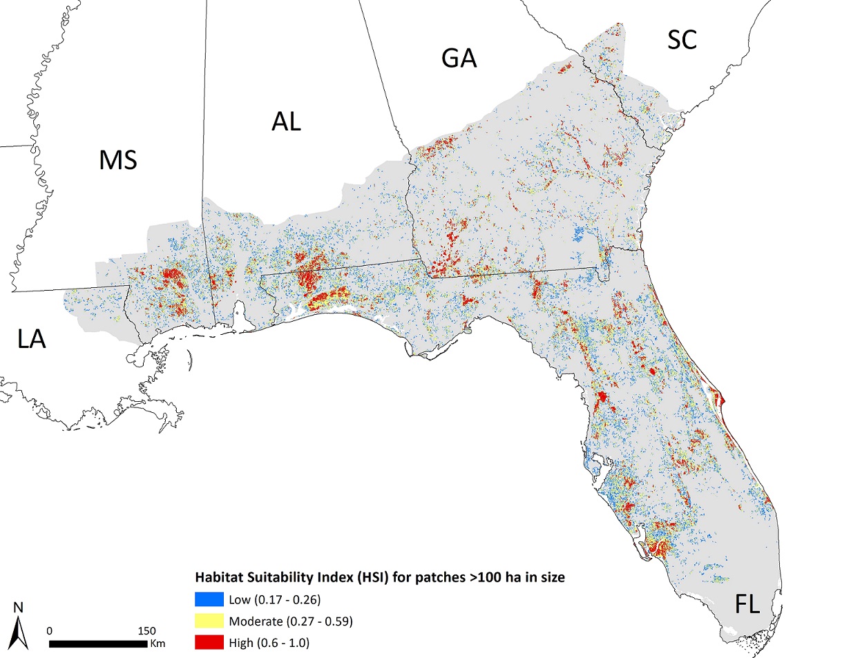
- 30-m rasters indicating the predicted habitat suitability index (between 0 [least suitable] and 100 [most suitable]) for each of 5 species evaluated
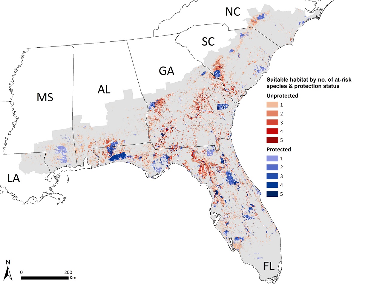
- Polygon shapefiles representing habitat suitability classes (low, moderate, and high suitability) for each species. Shapefiles also indicate if the habitat patch occurred on protected or unprotected lands, as shown in the map below.
We have also included a raster and shapefile indicating patches that were (a) large in size (> 1 sq-km) and (b) suitable for multiple species, which was of interest to some partners for prioritizing areas for management.
How best to use habitat suitability data
We hope these maps will add to the toolset of conservation planning in the Southeast at both local and range-wide scales. The habitat suitability maps have already informed the U.S. Fish and Wildlife Service’s Species Status Assessments (SSAs), which are used when making listing decisions, for the gopher tortoise and southern hognose snake. They will likely inform additional SSAs in the future. Regardless of final listing decisions, these species are declining across much of their ranges and are priorities for conservation planning for States and other partners across the Southeast.
Partners also could use products to:
-
Assess suitability at a local site known to be occupied by a species and tailor site-level management (e.g., increased use of prescribed fire)
-
Prioritize survey efforts in areas of high suitability without known or documented species records (e.g., on private lands)
-
Use the distribution of areas suitable for one or more species on protected or unprotected lands to identify priority areas for management, land acquisitions, or other strategies
Lastly, we should mention these are some of many other habitat suitability (or species distribution) models out there. Since none are perfect, we recommend consulting multiple habitat maps when using these products in conservation planning. A few examples of other existing datasets are (1) habitat models for 10 at-risk species, including the gopher frog, striped newt, and southern hognose snake developed by state natural heritage programs in a South Atlantic LCC-funded project, and (2) a pilot project to refine a subset of Southeast species models based on NatureServe’s forthcoming Map of Biodiversity Importance capturing over 2,000 at-risk species.
More info on what went into the models
Creation of these habitat suitability maps was certainly a long and detailed process, but we wanted to highlight one key aspect: collaboration with experts. With their help, we gathered and used a fairly comprehensive dataset of over 70,000 species location records to build habitat models. We also used knowledge from 30 species experts to improve these models at several stages. They helped us prioritize which environmental variables—like fire frequency and canopy cover—to evaluate as predictors of suitability. They helped us capture regional variation in models so that what makes habitat “good” for a species could change across its range. They helped us improve the quality of our final models by telling us (frankly) what was wrong about predictions from earlier versions. We are thankful for all their input and proud that we were able to reflect so much of their on-the-ground knowledge into habitat models. Using expert input not only increased the statistical performance and precision of our models, but also (hopefully) the degree partners trust and use these results.
Full details about our habitat suitability model work will be available in a paper currently being peer-reviewed, and we will send an update when it is published. In the meantime, check out this recording of a previous webinar that provides an overview of the project.
If you use these products in any reports/manuscripts, please use the following citation: Crawford, B.A., Maerz, J.C., and Moore, C.T., 2020, Range-wide habitat suitability maps for at-risk species in the longleaf system: U.S. Geological Survey data release, https://doi.org/10.5066/P92PZN7G.
Please contact Brian Crawford (bcrawfor@uga.edu) with any questions.