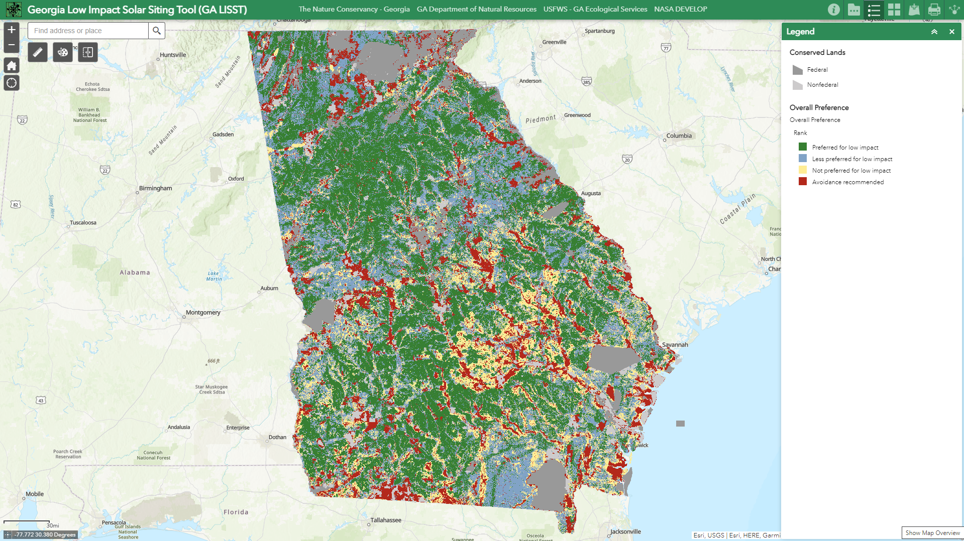
The Nature Conservancy uses the Blueprint to help inform low impact solar siting in Georgia

Rapid deployment of large-scale solar energy projects is critical to accelerate the transition to a cleaner energy future. Unfortunately, these projects currently require significant quantities of land. The Nature Conservancy (TNC) supports the acceleration of large-scale solar development when responsibly sited in areas of low environmental impact. Low impact siting principles help protect our most sensitive habitats while also providing more certainty for developers earlier in the process. Research indicates that using low impact siting principles can decrease reputational risk for developers and save money by avoiding project delays and public opposition. TNC in Georgia has worked together in partnership with conservation groups, developers, and utilities to launch a publicly available tool that can support Georgia decision-makers as they seek win-win outcomes for both conservation and decarbonization. The GA Low Impact Solar Siting Tool (GA LISST) is available to the public at http://bit.ly/GALowImpactSolar.
In order to analyze the growing conflict between solar development and sensitive habitats across Georgia, a Land Use Conflict Identification Strategy (LUCIS) approach was used. The foundational analysis was performed during three student project terms with the NASA DEVELOP program at the University of Georgia (2017-2020), and subsequent data refinement was completed in 2021. Partner engagement as well as comprehensive datasets like the South Atlantic Conservation Blueprint were critical for developing defensible and partner-supported rankings for both environmental sensitivity and solar suitability across Georgia. Once these rankings were created, bivariate analysis was used to spatially connect both rankings and allow for interpretation of both the suitability of a site for large-scale solar installations as well as the relative risk of that site being environmentally sensitive. To simplify the interpretation of these combined rankings, they were divided into four overall preference categories for low impact solar siting: preferred, less preferred, not preferred, and avoidance recommended. This analysis can be used to identify sensitive areas at greatest risk for conversion as well as highlight ideal opportunities for solar development in areas of low environmental impact.
For both environmental sensitivity and solar suitability, initial criteria were identified through the review of published literature and datasets and then refined based on feedback from partners that were most involved with solar development in Georgia. For environmental sensitivity, initial rankings were developed using both the Southeast Conservation Blueprint as well as TNC’s Resilient and Connected Lands datasets. From there, TNC in Georgia worked very closely with the GA Department of Natural Resources, the US Fish and Wildlife Service, and The Orianne Society to consider state-specific datasets that could enhance these base rankings to address locally observed or anticipated sources of conflict. This exercise resulted in the incorporation of habitat suitability rankings for the gopher tortoise and the eastern indigo snake as well as data for active riverine areas. For solar suitability, physical land characteristics such as proximity to transmission lines, solar insolation, slope and aspect, and existing land uses were assigned rankings and weights based on trade publications and other published literature. These were also refined through engagement with solar developers and Georgia Power representatives. Once finalized, a weighted ranking analysis was performed to develop suitability rankings for large-scale solar development across Georgia.