Working for wildlife – How SECAS is helping states and territories with their Wildlife Action Plans
What is a State Wildlife Action Plan?
Since 2005, every state and territorial fish and wildlife agency in our nation has produced a State Wildlife Action Plan (SWAP) and submitted it to the U.S. Fish and Wildlife Service for approval in order to receive funding through the State and Tribal Wildlife Grants programs. These plans must be updated every ten years. Congress requires that each SWAP addresses eight common elements to help guide each agency in identifying Species of Greatest Conservation Need (SGCN) and management actions to best manage and conserve those species.
While SWAPs share the eight required elements as a common framework, each plan is unique to its state or territory. These plans represent an amazing repository of science, expert opinion, and collaboration with partners and the wider public. Typically hundreds of pages long, these plans describe the distinctive habitats, SGCN, and conservation challenges and opportunities of the Southeast region.
While they are incredibly valuable for rallying conservation action among partners, writing and revising SWAPs is an intensive process. Staff from state and territorial fish and wildlife agencies spend countless hours researching, summarizing, and visualizing information. They bring together local biologists, scientists, experts, and conservation practitioners from universities, non-governmental organizations, Tribes, and federal and state agencies to inform the SWAPs. While synthesizing and incorporating all of this science and knowledge, our state and territorial partners are also reaching out to the public for feedback on these plans. And in the midst of all this work, it can be hard for SWAP Coordinators to stay in-the-know about what every other state and territory is doing for their SWAPs.
The Need for Regional Alignment
In 2021, the Wildlife Diversity Committee for the Southeastern Association of Fish and Wildlife Agencies (SEAFWA) conducted a survey of SWAP Coordinators in the Southeast to learn how each state or territory approaches their SWAP revisions, what tools they use, and what parts of developing and revising their SWAPs they find most challenging. The survey results found that identifying SGCN and incorporating climate change information were some of the most challenging components of the revisions. The survey also revealed that the states and territories felt that aligning SWAPs is important and share an interest in developing a template that provides guidance on how to populate chapters and address the eight required elements of a SWAP.
For SECAS, the survey results made it clear that we could help the states and territories with some of their challenges by adding capacity. We could connect the fish and wildlife agencies to regional conservation datasets like the Southeast Blueprint and facilitate communication among states and with other regional partners like the Southeast and South Central Climate Adaptation Science Centers (CASCs).
Adding Capacity to Connect with Regional Priorities
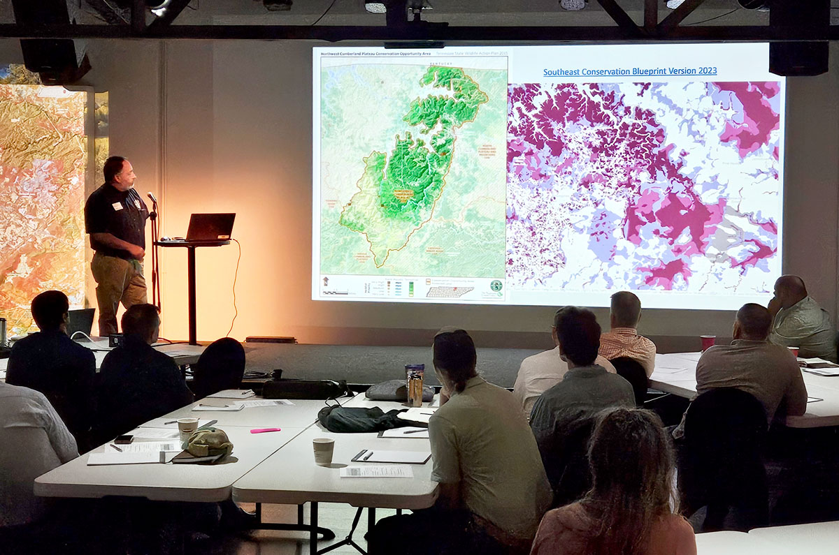
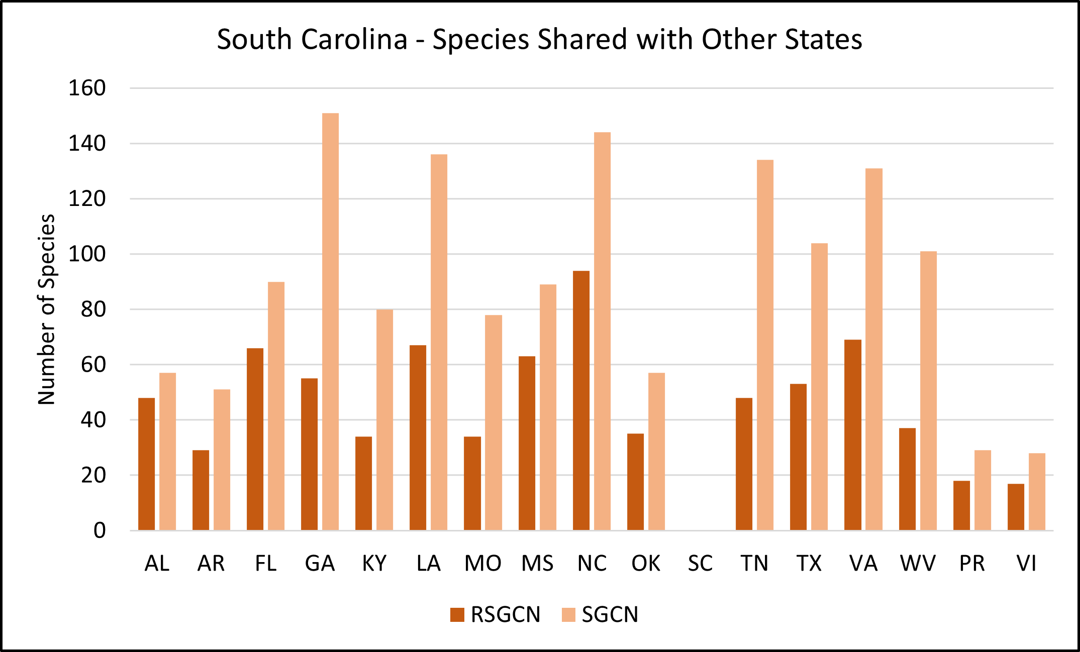
The Blueprint user support team is currently working with eight states (GA, MS, SC, NC, LA, AR, TN, OK), as well as Puerto Rico and the U.S. Virgin Islands, to help integrate the Blueprint into SWAP revisions (in addition to KY, who already used the Blueprint independently in its 2023 SWAP update). By using a consistent regional dataset along with local information, our state and territorial partners are identifying priority lands and waters that support SGCN and also align with their neighbors.
SECAS staff have also been writing additional chapters for the SWAPs to add capacity and help our partners overcome challenges. These chapters highlight how each state contributes to the regional landscape to promote conservation actions that will broadly benefit SGCN across their ranges. While each chapter follows a consistent format, the content is customized to each state. By drawing on existing regional information, these chapters help align SWAPs across the region and identify opportunities to work together, especially for Competitive State Wildlife Grants.
SECAS also recognizes that truly supporting the states and territories requires more than just pointing them in the direction of information. There’s no such thing as an idle SWAP Coordinator! Instead, staff are helping our partners access, summarize, and integrate that information into their SWAPs. This work dovetails with what our user support team does—helping people use the Blueprint and connecting them to other resources in order to inform and facilitate conservation actions.
Through these chapters, SECAS staff are working to help partners consider areas beyond their jurisdictional boundaries where conservation actions may influence their SGCN. In addition, our team use data sources like the Blueprint and its underlying connectivity analysis, the SECAS goal report, and plant and animal Regional SGCN to identify areas where statewide action can contribute to local and regional goals.
Integrating Climate Change Data
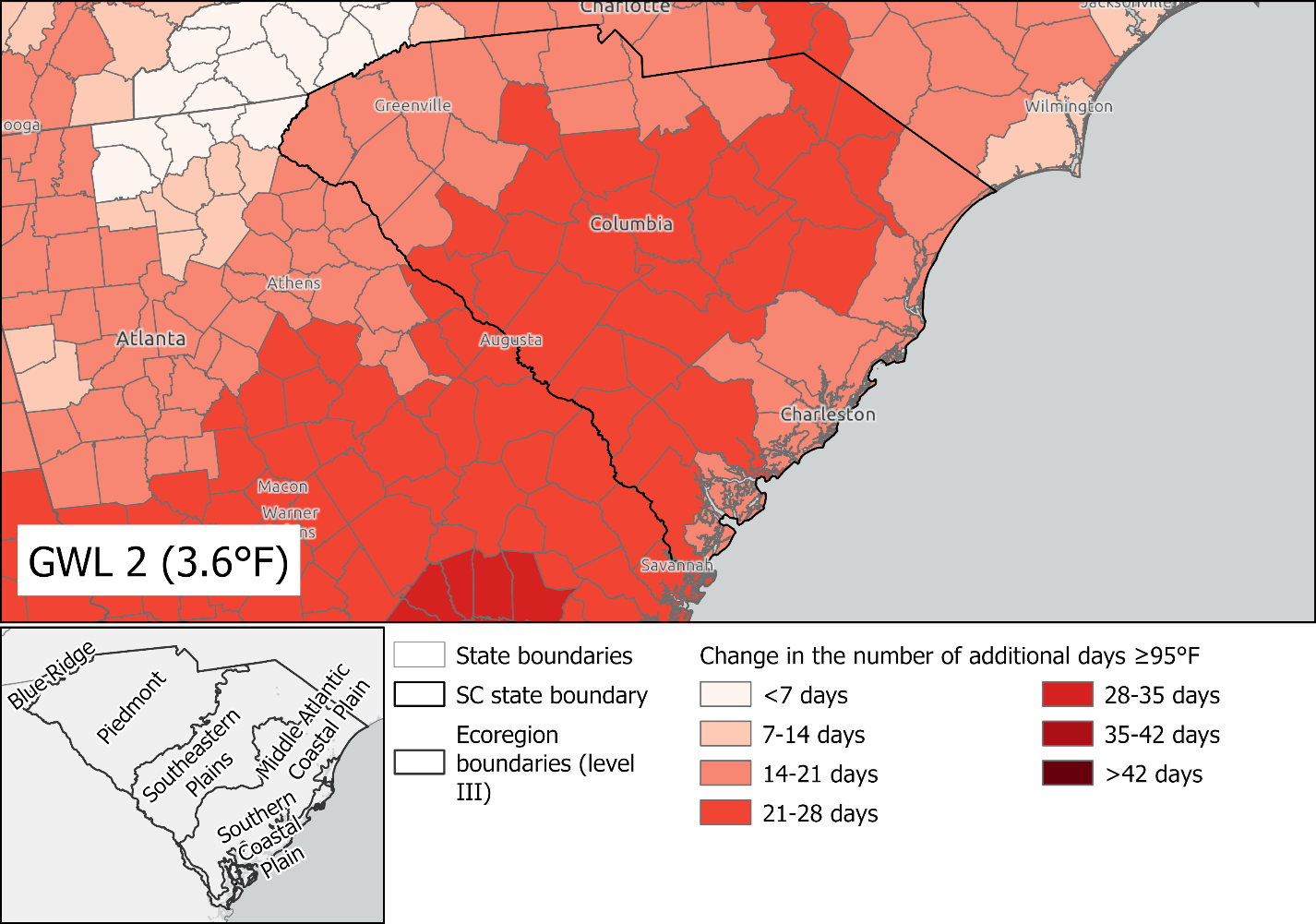
One of the most exciting outcomes from these regional chapters so far is that it has led to an important collaboration with the Southeast and South Central CASCs. Working closely with the states, SECAS and the CASCs are identifying the best available climate change data to inform SWAP adaptation and management strategies. Not only is this helping states better integrate climate change into their SWAPs, but the CASCs are shifting the way they engage with their partners by investing in user support capacity and helping them apply data to their work. The Blueprint user support team and staff from the CASCs are working together to use climate change tools and data and summarize findings on behalf of the states and territories.
Facilitating Cross-State Collaboration
Finally, while our staff work with each state individually, we can also share and facilitate knowledge across boundaries about what other states and territories are doing. With permission, we’ve shared methods about how some states develop their Conservation Opportunity Areas, which are priority areas for conserving SGCN. We’ve hosted webinars focused on how we can continue to conduct prescribed fire while meeting stronger national ambient air quality standards and how the state of Georgia is using their SWAP as a strategy to accomplish that. We’ve also changed the way we work to do a better job of offering resources, like adding statewide Blueprint reports on our website, and listening to our partners about how they would like to see information presented.
Working with our partners is a privilege, and the best way to build trust and accelerate conservation in the Southeast is for SECAS to support the SWAPs of our region. Once the 2025 SWAPs are complete and publicly available, they will help guide actions for our wider community and contribute to regional and national conservation priorities at a landscape scale.