Working to improve existing datasets - A spotlight on the Protected Areas Database
One of the guiding principles of SECAS is to avoid duplicating the good work of others. Whenever possible, we connect to existing partnerships and build on existing datasets. I see SECAS as an integrator, a synthesizer—helping the conservation community make the best of the resources we already have.
As a result, SECAS staff are big users of existing national and regional data products. Whether we’re using them to identify priority areas in the Southeast Conservation Blueprint or track change over time in the SECAS Goal Report, we have the unique opportunity to dig deeply into available layers and tools, test them against other state and local datasets, and collect feedback from our users. We know firsthand how meaningful user input can be! So when we find an issue in one of the datasets we’re using (because, let’s face it, no dataset is perfect—the Blueprint certainly isn’t!), we pay it forward by reporting it and advocating for future improvements.
This can take many forms. We’ve informed LANDFIRE that marinas sometimes get misclassified as forests because boat masts can look like trees on a satellite image. We successfully lobbied Esri to update their intact habitat cores dataset to more recent landcover. We’ve let the EPA know about floodplain errors in Texas. We’ve reported shoreline projection issues to NOAA. The list goes on!
Sometimes, this results in strong collaborative relationships with data providers, especially those who are committed to regular updates and responsive to user feedback. One team we’ve been fortunate to work with are the folks at the U.S. Geological Survey who develop the Protected Areas Database of the United States, affectionately known as PAD-US. Can we take a moment to just think about how hard their job is? Aggregating and standardizing existing source data sets to incorporate every land protection project, every easement, every transfer in ownership or change in designation type, every new city park, state forest, or land trust preserve, across the entire United States? That is a lot to keep track of! Behind the scenes, PAD-US staff also coordinate with and rely on data stewards and users from federal agencies, state agencies, and national non-profits to aggregate and develop the data, so I want to give a shout-out to these key partners as well for the critical role they play!
Our journey with PAD-US started in 2021 when Alex, a member of our user support team based in Atlanta, GA, noticed a local protected area polygon that that didn’t seem right. We were working on an update to the urban park size indicator, and this area didn’t look like a park at all. It turned out that the county-owned property, originally a parking area for a MARTA train station, had been sold and turned into residential and retail space as part of a transit-oriented development project. Since it was no longer protected, the PAD-US team was happy to remove it.
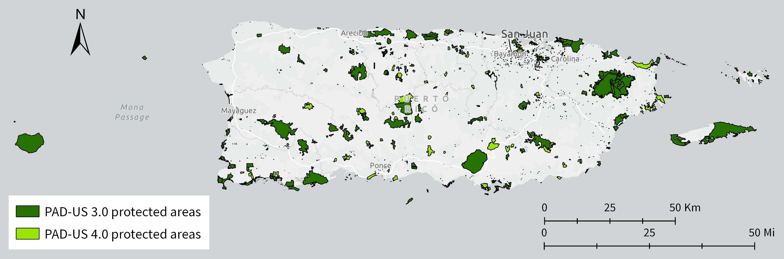
Empowered by this experience, lately we’ve been suggesting more improvements, especially in the U.S. Caribbean as part of our ongoing commitment to addressing data inequities there! Last year, we connected PAD-US staff with a Puerto Rico protected areas dataset developed by an inter-agency partnership, which I’m happy to report significantly improved protected areas coverage in the recent update to PAD-US version 4.0. We’ve since shared an additional U.S. Caribbean protected areas dataset maintained by The Nature Conservancy (TNC), which we hope will be incorporated in the next update and improve coverage of TNC’s U.S. Virgin Islands preserves. We’re also helping lay the groundwork for the new Territorial Parks System in the U.S. Virgin Islands to report their protected areas to PAD-US.
Back in the continental Southeast, we recently notified the PAD-US team that many Wildlife Management Areas (WMAs) in Oklahoma unfortunately dropped out in version 4.0 due to a technical error that will hopefully be corrected in the next update. If this affects you, our workaround was to extract the Oklahoma WMAs from PAD 3.0 and splice them in—we’d be happy to share our approach, so feel free to reach out to me if you have questions (email hilary_morris@fws.gov).
Our most ambitious collaboration yet—still a work in progress—has brought together staff from PAD-US, the U.S. Fish and Wildlife Service, the National Park Service, and the National Oceanic and Atmospheric Administration (NOAA). NOAA maintains the official national Marine Protected Areas (MPA) Inventory, which feeds into the marine layer of PAD-US. While working to expand the urban park size indicator to nearshore marine parks, SECAS staff discovered errors in the boundaries of a number of federally managed MPAs. While these were already fixed in the various inland PAD-US layers (like fee, designation, and easement), the marine layer was out of sync and did not yet reflect the updated boundaries. As a result, when we combined the marine and inland layers to create the urban park size indicator, our park footprints were off-base. Everyone has gamely chipped in to streamline data-sharing processes, identify new agency points of contact, and deliver improved data. I’m optimistic we’ll be able to correct these mismatches in the future.
I commend the PAD-US team for being so approachable and feedback-oriented. To me, this collaboration exemplifies the lean startup method and illustrates the value of working to improve existing tools and resources. Together, we can make sure that these foundational datasets work better for everyone and avoid the dreaded reinvention of the wheel. If you want to share comments or updated protected areas information with the PAD-US team, you can contact them at pad-us@usgs.gov. I’m also happy to help coordinate!