Southeast Blueprint Explorer viewer updated with 2022 data
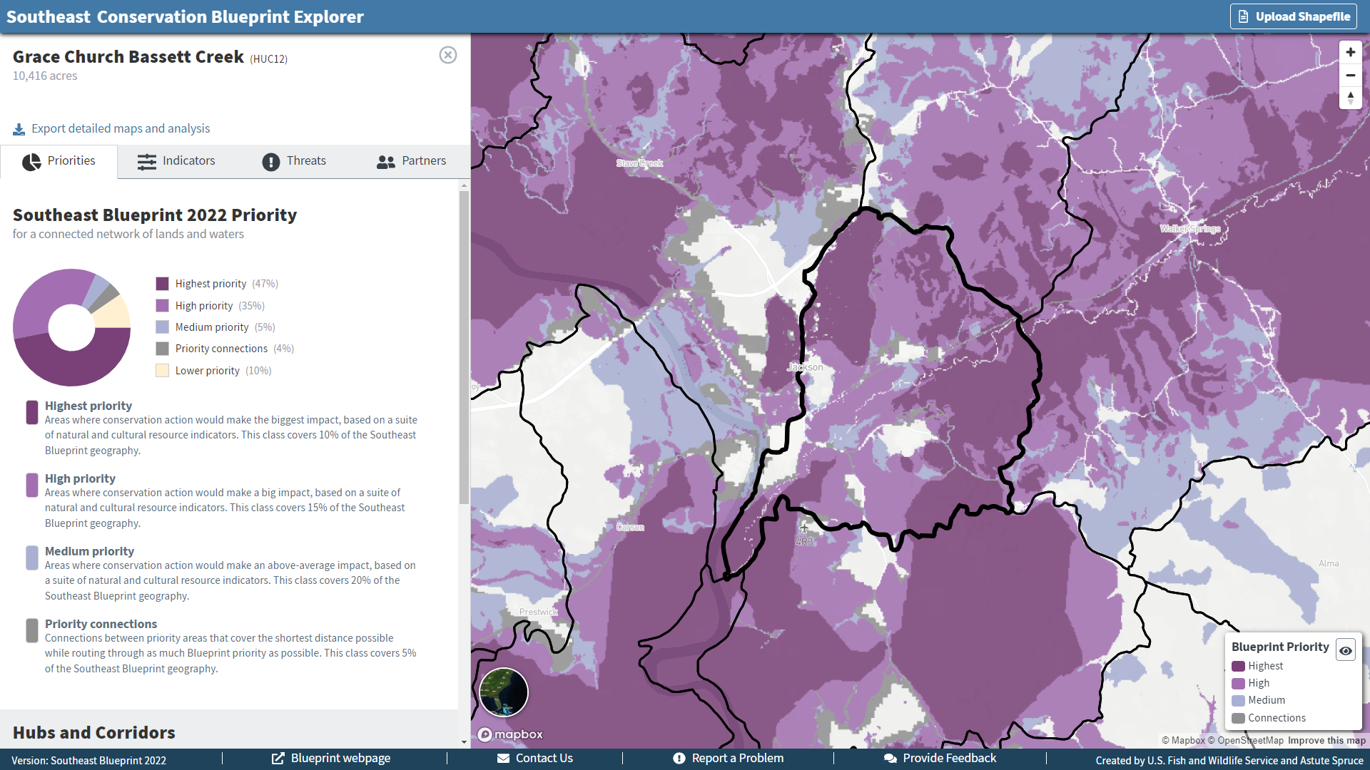
The Southeast Blueprint Explorer has been updated with the latest data for Southeast Blueprint 2022! This easy-to-use online viewer is a great place to start exploring the Blueprint and the underlying data–no GIS experience or fancy software licenses required! The Explorer is a big part of our commitment to making the Blueprint accessible to everyone.
Huge thanks to Brendan Ward with Astute Spruce for his oustanding work designing the Explorer and updating the data! Now you can see the new Blueprint priorities, indicators, corridors, threats, and more summarized by 12-digit HUC subwatershed and marine lease block. You can export reports for those summary areas or upload your own shapefile and create a custom report full of detailed maps and analysis.
In addition to updating the Blueprint data, we also updated the urbanization and sea-level rise (SLR) projections. We replaced the now-outdated SLEUTH urban growth data with brand new FUTURES urban growth data from the Center for Geospatial Analytics at NC State University. To help put future urban growth predictions into the context of recent historical change, we also added past urban growth trends since 2000 from the National Land Cover Database.
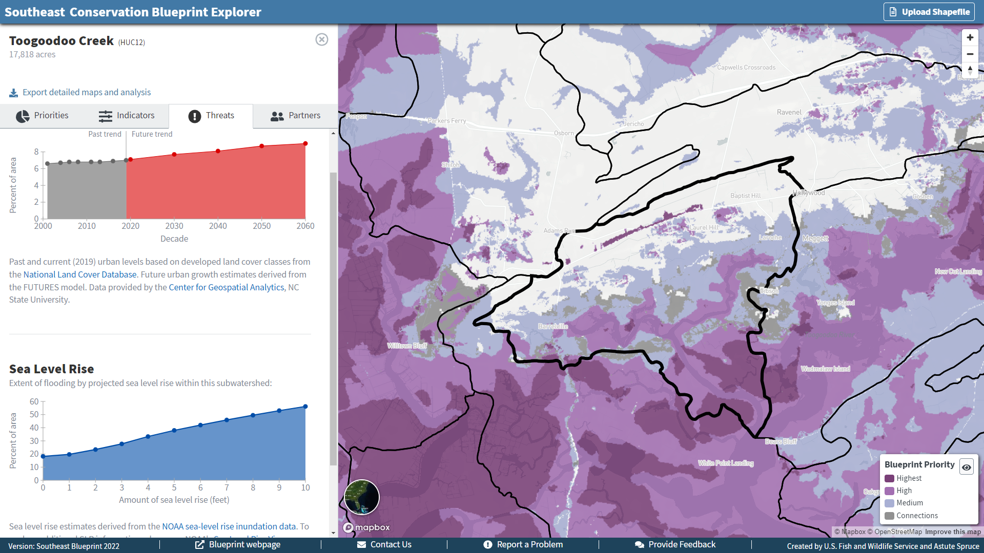
We expanded the SLR information by including NOAA’s SLR inundation model projections out to 10 feet of SLR, an improvement over the 6 ft available in the previous beta version of the viewer. In the reporting, we also paired the inundation projections with data from NOAA’s 2022 Sea-Level Rise Report showing the amount of sea-level rise predicted to occur in an area during each decade out to 2100 under scenarios ranging from low-high SLR. Because the NOAA inundation models aren’t linked to time, this provides valuable information on when an area is likely to experience a given amount of flooding.
What else is new? The land protection status information now draws from the latest version of the Protected Areas Database, PAD-US 3.0. And the search for nearby land trusts to collaborate with now uses a more intuitive search radius instead of listing land trusts by county.
We’re still hard at work on some other exciting updates that we hope to make avaialable by the end of this year, including pixel mode and filtering. Pixel mode will allow you to drill into the smallest unit of the Blueprint, an individual 30x30 m pixel, to see what is driving the Blueprint priorities. This functionality was available in the South Atlantic version of this viewer, and we’re making it available in the Southeast Blueprint Explorer as well.
Filtering will allow you to use the indicators and other data to find the part of the Blueprint that you’re most interested in. If you are looking for areas to protect bottomland hardwood forest to benefit interior forest breeding birds in the Mississippi Alluvial Valley, you’ll be able to see the part of the Blueprint that scores highly on the MAV Forest Birds - Protection indicator. If you are looking for areas to restore riparian buffers, you’ll be able to see the part of the Blueprint that scores in a particular range on the natural landcover in the floodplain indicator. If you’re looking for places to create new open space to fill park access gaps in socially vulnerable communities, you’ll be able to see the part of the Blueprint that scores highly on the equitable access to potential parks indicator.
User support can help you answer those sorts of questions now, so if you want some help finding the part of the Blueprint that best aligns with your mission and interests, please reach out to a member of the user support team. You can find our contact information on the SECAS staff page. We’re really excited about this new version of the Blueprint and would love to work with you!