July 15th webinar on using fire regimes as ecosystem indicators
Webinar details
- Title: Using fire regimes as ecosystem indicators: SEFireMap, Southeast Conservation Blueprint, and other applications
- Speakers: Joe Noble and Eli Simonson, Tall Timbers Research Station, and Rua Mordecai, South Atlantic and Southeast Blueprints
- Date: Thursday, July 15th
- Time: 10:00 am Eastern
- Connection information: Join Microsoft Teams meeting (Note - no registration required, just click to join the webinar when the time comes!)
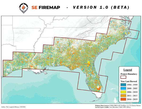
The July South Atlantic Third Thursday Web Forum will focus on the use of fire regimes as ecosystem indicators. Joe will provide some background on the new fire regime data from the SEFireMap project. The SE FireMap is a new fire mapping system for the Southeastern United States. Developed with funding provided by the USDA NRCS, SE FireMap uses a remote sensing based approach to track both prescribed fire and wildfire activity on public and private lands across the range of the longleaf pine. SE FireMap is being developed as a critical decision support tool to maximize the effectiveness of fire management practices across boundaries, ecosystems, and jurisdictions. Eli will then talk about how Tall Timbers Research Station has been using SEFireMap data in their conservation planning. Rua will discuss how the South Atlantic and Southeast Blueprints are using the SEFireMap data. Finally, they’ll all tie it together by talking about challenges and opportunities with using fire regimes as ecosystem indicators.
A recording will be posted afterwards to the calendar event on the South Atlantic website, if you’re unable to make the webinar.