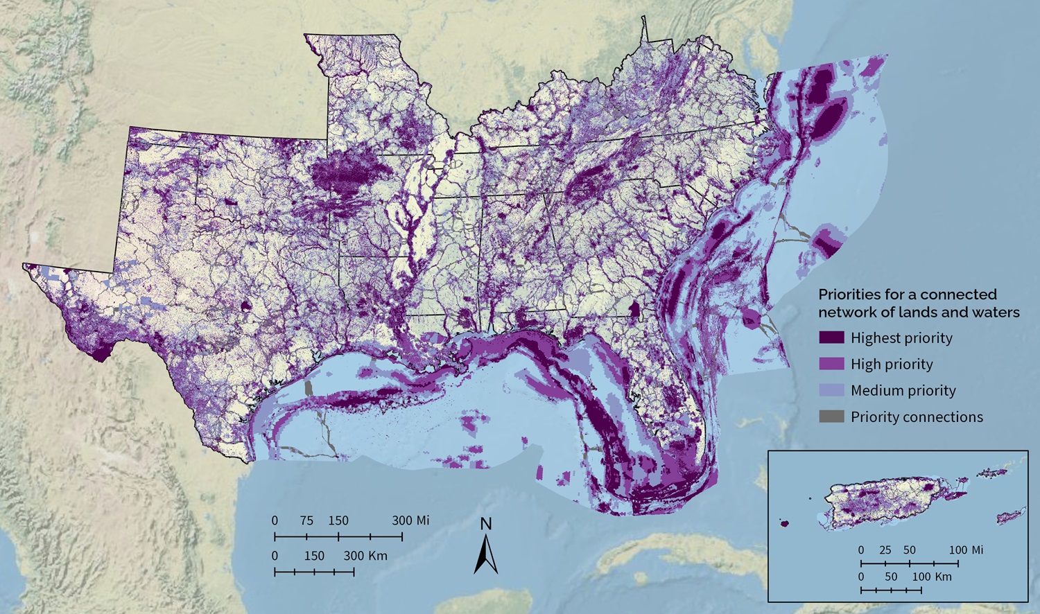
Southeast Conservation Blueprint 2025 now available
“Year after year, SECAS continues to deliver on its promise of supporting a conservation vision for connected lands and waters across the Southeast and Caribbean. The data-driven, regional approach is best demonstrated by its flagship tool, the Blueprint. The Blueprint is updated annually based on feedback from partners in member states to highlight regional goals that can be downscaled to achievable, on-the-ground project spaces. This achievement is based on the active engagement of our partners and the responsive community of Blueprint users. Enjoy the newest edition of the Blueprint!”
–Nicole Angeli, SECAS Executive Steering Committee Chair and Director of the Fish & Wildlife Division at the U.S. Virgin Islands Department of Planning and Natural Resources
The latest update to the Southeast Conservation Blueprint, version 2025, is now available! Here are the major improvements for this year:
NEW INDICATORS
- Imperiled mammals identifies potential habitat to support mammal Regional Species of Greatest Conservation Need (RSGCN).
- Imperiled amphibians and reptiles identifies potential habitat to support amphibian and reptile Regional Species of Greatest Conservation Need (RSGCN).
- U.S. Virgin Islands imperiled species identifies potential habitat to support terrestrial species across the U.S. Virgin Islands.
- River cane restoration represents priority places for river cane restoration and co-stewardship near the lands of federally recognized Tribes.
- Grassland & savanna restoration represents potential restoration opportunities for grasslands and savannas within their historic range in the southeastern United States.
- Lakes & reservoirs assesses the condition of lakes and reservoirs based on the amount of natural landcover within the upstream watershed.
- Floodplain inundation uses the frequency of inundation to measure the hydrologic function of the floodplain.
- Puerto Rico potential access to parks prioritizes places to create new parks that would fill gaps in access to open space within socially vulnerable communities in urban areas.
- Caribbean mangrove migration represents current and potential future locations of mangroves based on land cover and barriers to mangrove migration like slope, elevation, and development.
MAJOR INDICATOR UPDATES
- Grassland & savanna extent (previously grasslands and savannas) now has an improved way to deal with tree encroachment in historically treeless grasslands, a new approach for clustering using grassland & savanna hubs, better identification of likely grasslands & savannas, new known grasslands, and other improvements. It also has a new name to reduce confusion with the new grassland & savanna restoration indicators.
- Landscape condition now treats tree encroached grasslands out West as altered, treats the open water in reservoirs as altered, and uses the latest grassland & savanna extent indicator to correct for misclassification of grassland & savanna.
INDICATOR “CHEAT SHEET”
- There’s an updated overview of all indicators in the 2025 Blueprint in the indicator “cheat sheet”
IMPROVED PRIORITIZATION METHODS
- Thanks to the new lakes and reservoirs indicator, the Blueprint priorities now include the open water areas of reservoirs.
- Puerto Rico and the U.S. Virgin Islands are now in separate analysis zones. This allows the use of indicators where information is only available in one but not the other. For 2025, that meant to inclusion of potential access to parks in Puerto Rico and a new imperiled species indicator in the U.S. Virgin Islands.
IMPROVED CORRIDORS
- The corridors better incorporate existing connectivity priorities. The new methods use the VA Wildlife Corridor Action Plan, the FL Ecological Greenways Network/Florida Wildlife Corridor, and connectivity-based Conservation Opportunity Areas from the State Wildlife Action Plans for GA, SC, and NC to encourage the Blueprint corridors to follow those identified corridors. We plan to expand this approach to other states in future Blueprint updates.
- The marine corridors once again use marine mammal and sea turtle movement areas. We removed that approach in 2024 to simplify and streamline the corridor methods but found they helped refine the marine corridor routing and are now back for 2025.
- New hub methods reduce the influence of extremely long and narrow protected areas like the Natchez Trace Parkway. Parkways can still influence corridor routing–they’re just less likely to show up as hubs.
- Smaller hub size thresholds in the Caribbean helped improve the terrestrial corridors in the U.S. Virgin Islands.
EXPLORE THE DATA, LEARN MORE, AND GET HELP
You can explore the new data on the Blueprint Explorer. The Explorer is a Google Maps-style interface that lets you quickly summarize and explore Blueprint information. This is also the interface that lets you upload shapefiles and get fancy reports with things like indicator tables/maps and information on sea-level rise and urban growth for your specific area.
The Blueprint data and documentation are also available on the Blueprint page of the SECAS Atlas. The SECAS Atlas is an online mapping platform built in ArcGIS Hub. In the Atlas, you can download the data and documentation, view individual indicators, and make maps with Blueprint layers and other data. There’s even a quick start map that includes all the indicators and other underlying Blueprint data.
We’re also happy to help if you’d just like help incorporating this latest version of the Blueprint in your work. You can contact a member of the user support team and they’ll help you with things like making maps and combining Blueprint info with other local data and information you have.
Want to learn more and ask questions about this Blueprint update? Register for the December web forum on 12/11 @ 10am ET.
If you’re hungry for still more details on what’s new with this year’s Blueprint, check out the updated Blueprint changelog which documents all the changes we made in the 2025 update. It’s included in the Blueprint download package.